
Marine biodiversity monitoring map
This map enables researchers and users to discover where marine biodiversity monitoring (MBM) (time-series) is underway in Europe.
Navigate the map to access the associated metadata.
REGISTRATION
This LTSWG is open to new members interested in the topic. To become a member contact: Mark John Costello.
PLANNED INVOLVEMENT OF EUROMARINE ORGANISATIONS
Manager
NORD university
Co-Organisers
VLIZ, IRB, SDU, UHEL, IFREMER, AWI, GEOMAR, NUIG, UniP, GELIFES, NTNU, CIIMAR, CCMAR, MARE, CSIC, UCA, HCMR, CBMA
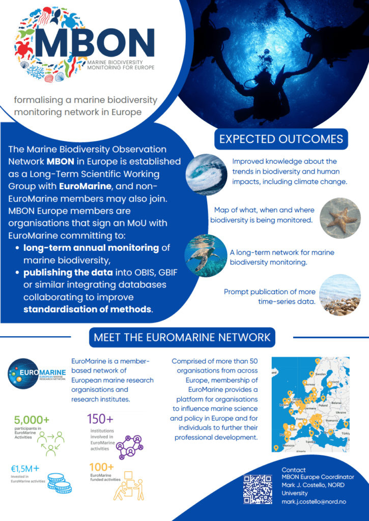
Long term monitoring, or time-series data, are the only way we know how biodiversity is changing in time. This knowledge and understanding has become more in demand because climate change now adds to the existing human impacts, including fishing and pollution. It enables confirmation and correction of models predicting changes in biodiversity.
For decades we have seen short-term efforts to coordinate and increase the collection of repeated and comparable marine biodiversity data, sometimes within particular habitats like shallow sediments and rocky seashores. These “time-series” datasets vary by habitat, frequency of sampling and species identified, and may be called “monitoring”. However, when short term project funding ends the coordination ends. We no longer know if the monitoring has continued or not. MBON-Europe will provide a permanent structure to recognise where, when and what marine biodiversity is being monitored in Europe.
Marine biodiversity monitoring is typically led by enthusiastic scientists. However, they cannot do the monitoring forever. Thus, a key task of MBON Europe is to make such monitoring a normal part of operations at an organisation, be it a field station, university, or government institute. To this end, we propose an MoU that will state a commitment by an organisation to long term monitoring of marine biodiversity to be signed between each MBON Europe participant and EuroMarine.
A significant advance since 2000 has been the development of standards for data formatting that aid its publication into global databases that integrate thousands of diverse biodiversity datasets, notably the Global Biodiversity Information Facility (GBIF) and its marine equivalent the Ocean Biodiversity Information System (OBIS). Monitoring is not complete until the data are published. Thus, the publication of datasets into OBIS (or GBIF) is a key measure of the success of marine biodiversity monitoring.
The idea of long-term monitoring of marine biodiversity is an old one, with many previous efforts (e.g., BioMARE). In recent decades, policy-relevant scientific insights from such data are being published in top journals because they show how human impacts, including climate change, are altering the natural environment. This demand increases the value of past and present biodiversity monitoring data.
MBON Europe will benefit the science by getting formal institutional recognition of marine biodiversity monitoring. It fits perfectly within the goals of the Group on Earth Observations, UN Decade of Ocean Science for Sustainable Development on “MarineLife2030 Programme”, UN Sustainable Development Goal 14 (life underwater) and Convention on Biological Diversity goals and targets (formerly Aichi Targets, now Global Biodiversity Framework).
Both Horizon Europe and BioDiversa calls for research projects have noted the need for supporting marine biodiversity monitoring and associated data analysis. MBON Europe will provide a ready-to-go network of organisations actively doing such monitoring and who could contribute to such research projects. MBON-Europe participants are thus well positioned to apply for funding for projects that require empirical data on trends in biodiversity over time and which can be placed in to a regional and global context.
Several MBON-Europe participants are collaborating with MarineGEO, led by the Smithsonian Institution and a core part of MBON globally, including MarineLife2030. MBON Europe will provide a forum to expand MarineGEO time-series and ecological experiments in Europe.
MBON Europe will provide opportunities for participants to compare best practice, exchange taxonomic skills, test and develop new methods including automation of sampling (e.g., video and photograph image analysis). There are likely to be serendipitous benefits to participants not presently imaged.
Government policy and society benefit from knowing how marine biodiversity is changing, for example local impacts due to pollution or over-fishing, marine litter, regional effects of climate change on species distributions, and the spread of invasive species. When the evidence is available then people and their governments are motivated to reduce such negative impacts. However, the necessary data are rarely accessible in a coordinated or timely way to inform society. The best understanding of change in biodiversity, including its causes and significance, is achieved when local studies can be placed into a regional and global context. For example, the local decline of a valued species may be due to some local impact or be part of a regional scale phenomenon, and knowing trends over decades is necessary to best understand the natural dynamics in ecosystems. Research projects cannot achieve the delivery of time-series data because of their short-term nature. The monitoring of biodiversity data needs to be mainstreamed into the annual operations of research organisations, with cost efficient and timely publication of standardised data that enables rapid analysis of trends in space and time.
In addition, the involvement of citizen science is being encouraged in Europe. The Reef Life Survey is part of the global MBON and depends on citizen science scuba divers and is ready for development in Europe. There are other examples, e.g. hundreds of European and Marine projects in iNaturalist, Jellywatch, Medjelly, eBird , Observadores del Mar (Sea Watchers), national recording programmes, and opportunities for citizen engagement. MBON Europe could also include citizen science initiatives to widen its data collection and improve public engagement.
In some cases monitoring occurred inside and outside Marine Protected Areas. European countries have committed to increasing MPA cover to 30% by 2030. There will be some demand for monitoring in these MPA to see if protection results in a restoration and recovery of biodiversity.
MBON Europe will benefit the science by getting formal institutional recognition of marine biodiversity monitoring. It fits perfectly within the goals of the Group on Earth Observations, UN Decade of Ocean Science for Sustainable Development on “MarineLife2030 Programme”, UN Sustainable Development Goal 14 (life underwater) and Convention on Biological Diversity goals and targets (formerly Aichi Targets, now Global Biodiversity Framework).
Both Horizon Europe and BioDiversa calls for research projects have noted the need for supporting marine biodiversity monitoring and associated data analysis. MBON Europe will provide a ready-to-go network of organisations actively doing such monitoring and who could contribute to such research projects. MBON-Europe participants are thus well positioned to apply for funding for projects that require empirical data on trends in biodiversity over time and which can be placed in to a regional and global context.
Several MBON-Europe participants are collaborating with MarineGEO, led by the Smithsonian Institution and a core part of MBON globally, including MarineLife2030. MBON Europe will provide a forum to expand MarineGEO time-series and ecological experiments in Europe.
MBON Europe will provide opportunities for participants to compare best practice, exchange taxonomic skills, test and develop new methods including automation of sampling (e.g., video and photograph image analysis). There are likely to be serendipitous benefits to participants not presently imaged.
We expect the following outcomes from MBON-Europe:
14:00 – 14:15 | Welcome and Introduction to LifeWatch Thematic Core Service (TCS) by Antonello Provenzale (CNR) and Alberto Basset (University of Salento)
14:15 – 14:45 | Individual Metabolic Responses to Climate Warming Depend on Biological and Ecological Context by Doug S. Glazier (Juniata College, USA; Online)
14:45 – 15:00 | Discussion
15:00 – 15:15 | Using Artificial Intelligence for estimating the Responses of coastal lagoons to Climate Change by Piero Lionello (University of Salento; In-Person)
15:15 – 15:30 | Energetic and Behavioral Responses of Aquatic Ectotherms to Projected Climate Change by Milad Shokri (University of Salento; In-Person)NR; Online) e/o Pasquale Bove (CNR; In-Person)
15:30 – 15:45 | Climate Change Effects on Animal Presence in the Massaciuccoli Lake Basin by Gianpaolo Coro (CNR; Online) e/o Pasquale Bove (CNR; In-Person)
15:45 – 16:00 | Empowering Environmental Science and Climate Change Study with DataLabs: LifeWatch’s Collaborative Coding Platform for Biodiversity and Ecosystem Research by Francesco De Leo (CNR, In-Person)
16:00 – 16:15 | Discussion
16:15 – 16:45 | Coffee break
16:45 – 17:00 | Ecological Resilience of Mediterranean Forests to Climate Change and Wildfires by Mara Baudena (CNR; Online)
17:00 – 17:15 | Cellular Automata Models for Wildfire-Vegetation Interaction by Paolo Fiorucci (Cima Research Foundation; In-Person)
17:15 – 17:30 | A Vegetation Simulation Platform in a Global Change Context by Alessio Collalti (CNR; Online)
17:30 – 17:45 | Discussion
17:45 – 18:00 | Identifying the environmental drivers of carbon fluxes – a step to assess climate change impacts on ecosystems by Marta Magnani (CNR; online)
18:00 – 18:15 | Modelling of Soil Organic Carbon dynamics in wetlands by Carmela Marangi (CNR; In-Person)
18:15 – 18:30 | Monitoring aquatic primary producers response to Climate Change: The Phytoplankton VRE by Jessica Titocci (CNR; In-Person)
18:30 – 19:00 | Discussion and Conclusion
09:30 – 10:00 | Wrap-up by Alberto Basset and Antonello Provenzale
10:00 – 11:00 | Community requirements and construction priorities
Topic 1 – What is Already in Place in Terms of Services (Within and Outside of LifeWatch ERIC)?
Topic 2 – Community’s Needs and Requirements: How Can We Identify These?
11:00 – 11:30 | Coffee Break
11:30 – 12:30 | Organising the Ecological responses to climate change working group
Topic 3 – Launch and lines of operation
Topic 4 – Collaborations and Project Research Initiatives
12:30 – 13:00 | Closing Remarks and Future Directions
Summarize key insights from the workshop and discuss potential avenues for future collaborations and research initiatives.
Welcome and Introduction to LifeWatch Thematic Core Service (TCS)
Individual Metabolic Responses to Climate Warming Depend on Biological and Ecological Context
Using Artificial Intelligence for estimating the Responses of coastal lagoons to Climate Change
Energetic and Behavioral Responses of Aquatic Ectotherms to Projected Climate Change
Climate Change Effects on Animal Presence in the Massaciuccoli Lake Basin
Empowering Environmental Science and Climate Change Study with DataLabs: LifeWatch’s Collaborative Coding Platform for Biodiversity and Ecosystem Research
Ecological Resilience of Mediterranean Forests to Climate Change and Wildfires
Cellular Automata Models for Wildfire-Vegetation Interaction
A Vegetation Simulation Platform in a Global Change Context
Identifying the environmental drivers of carbon fluxes – a step to assess climate change impacts on ecosystems
Modelling of Soil Organic Carbon dynamics in wetlands
Monitoring aquatic primary producers response to Climate Change: The Phytoplankton VRE
Ecosystems and biodiversity are currently under threat owing to many different manageable and unmanageable anthropic pressures. Among these, climate changes are unmanageable pressures, which can have direct impact on ecosystems and biodiversity, pushing populations to abandon traditional distribution areas and move to new territories, favouring the spread of allochthonous species, reducing the survival of endemic and/or specialised organisms, leading to impoverished ecosystems more prone to collapse. Ecological responses to climate change include also increasing individual level respiration rates, altering species interaction networks and ecosystem process rates, leading to lower net primary productivity and standing biomass. Climate change can have indirect amplifying effects on other anthropogenic threats, such as pollution, land degradation and fragmentation, and the diffusion of invasive species; ecological responses to climate change can also have indirect effects on human well-being.
In this workshop, organised with LifeWatch Italy, we intend to explore the role of LifeWatch ERIC in developing a suite tool and services on data curation, data analysis and modelling, to better understand ecological responses to climate change, describe scenarios of biodiversity and ecosystem functioning change under climate change, considering in particular how such changes affect ecosystem integrity and to what extent they could harm and decrease the benefits that healthy ecosystems provide to human beings.
Since ecosystems include biotic and abiotic components that form a complex network of interactions, particular attention will be given to biological and mathematical models that consider:
The following main objectives are envisaged for the Working Groups:

The kick-off Workshop, focusing on the Taxonomy Thematic Services, has been proposed and organised by LifeWatch Belgium in collaboration with all LifeWatch Common Facilities and National Distributed Centers. The workshop took place in Brussels on January 30th, concurrently with the LifeWatch Belgium Biodiversity Day. The workshop also launches the constitution of LifeWatch ERIC Working Groups on the Thematic Services, engaging participants from all LifeWatch National Distributed Centers and Common Facilities in an open discussion on the current state of the Taxonomy Services, their actual matching with the scientific community needs and requirements and the approaches and priorities of the Taxonomy Services’ Working Group for further integration and improvement of LifeWatch Taxonomy Services and user engagement.
30/01
10:00 | Welcome
10:05 – 10:20 | Introduction LifeWatch Thematic Core Service (TCS) by Alberto Basset (LifeWatch Service Center).
10:20 – 10:30 | Defining the scope of the TCS Taxonomy Services (TCS) by Leen Vandepitte (LifeWatch Belgium) + Discussion.
10:30 – 11:00 | What is already in place in terms of taxonomic services (within and outside of LifeWatch)? by Stefanie Dekeyzer (LifeWatch Belgium) + Discussion.
11:00 – 11:30 | What are the needs and requirements from the community or how can we identify these? by Leen Vandepitte (LifeWatch Belgium) + Discussion.
11:30 – 11:45 | How can we further integrate this into the infrastructure? (Discussion).
11:45 – 12:00 | How to organize this TCS-community interaction for the future? (Discussion).
12:00 | Closing of the meeting
10:00 | Welcome
10:05 – 10:20 | Introduction LifeWatch Thematic Core Service (TCS) by Alberto Basset (LifeWatch Service Centre)
10:20 – 10:30 | Defining the scope of the TCS Animal Behavior and biologging Services by Jan Reubens (LifeWatch Belgium) + Discussion
10:30 – 11:00 | What is already in place in terms of services (within and outside of LifeWatch)? – Compiled presentation based on received input
11:00 – 11:30 | What are the needs and requirements from the community or how can we identify these? – Discussion on stakeholders to involve
11:30 – 11:45 | How can we further integrate this in the infrastructure? – Discussion
11:45 – 12:00 | How to organize this TCS-community interaction for the future? – Discussion
12:00 | Closing of the meeting
Introduction to LifeWatch Thematic Core Services
Developing databases with orchids as target group
Conservation biogeography; migration, isolation, and barriers in changing climate.
Linking Earth Observation with Emerging Risks of Wildfires in European Temperate Forests
Plant diversity in Italy across biogeographical gradients and human history
Diversity and distribution of alpine ecosystems
Organisms and biological communities vary along geographic space both in relation to the gradients of latitude, elevation, isolation and habitat area. In addition, the species composition of the local or regional assemblages varies across space and time depending on evolutionary and ecological pressures. This makes biodiversity not evenly distributed in space, with some regions hosting significantly more species than others. Climatic and land use changes affect species’ biogeographical distribution and abundance. Often, these changes determine the reduction of the number of individuals and range size of species, but opposite patterns are typically observed for alien invasive species. The changes in abundance and distribution of species determine a continuous transformation of species assemblages. This is very interesting for establishing basic studies of general conservation strategies and species conservation planning actions.
In this workshop organised with LifeWatch Italy, we intend to explore the role of LifeWatch ERIC in developing a suite of tools and services on data curation, data analysis and modelling to better understand biogeographical gradients in space and time and to model future changes in response to climate change or conservation strategies.
4th April (14.30-19.00)
5th April (9.00-12.00)
The Biodiversity Observatory Automation, part of our Thematic Service Workshop Series, is dedicated to reviewing and updating the requirements for effective biodiversity assessment in an era of unprecedented environmental change and biodiversity loss.
Although biodiversity assessment can be challenging due to time-consuming fieldwork and demanding post-fieldwork data processing and storage, advances in automation of data collection, increasing computational power, and artificial intelligence offer new possibilities.
The workshop, hosted by LifeWatch Slovenia, will bring together experts to present key achievements and obstacles in monitoring and observational approaches and discuss the drawbacks and needs of different stakeholders. In this workshop, we will explore the possibilities offered by a variety of modern approaches to monitoring and detecting biodiversity (from aerial observations to eDNA), from data collection design, data curation, and data exploration, including the use of AI to FARIfication of data to digital twins.
09:00 – 09:10 | Greetings from Slovenian hosts – Tanja Pipan and Andreja Ramšak (LifeWatch-SI)
09:10 – 09:30 | Presentation of Thematic Core Services (TCS) – Alberto Basset (LifeWatch ERIC Service Center)
09:30 – 10:10 | Invited talk: Ecosystem Virtual research environment: from data FARIfication to digital twins – Zhiming Zhao (University of Amsterdam)
10:10 – 10:25 | Talk: Challenges to Implement Darwin Core Meta Data Standard within GeoNetwork portals – Magdalena Năpăruş-Aljančič, Žan Kafol and Tanja Pipan (Karst Research Institute ZRC SAZU)
10:25 – 10:40 | Talk: Case study: Landscape features and biodiversity in agroecosystem – Danijel Ivajnšič and Nataša Pipenbaher (University of Maribor)
10:40 – 11:20 | Invited talk: Using high-throughput species discovery with robots and Nanopore sequencing to overcome taxon biases in biodiversity science – Rudolf Meier (Museum of Natural History, Berlin)
11:20 – 11:30 | Coffee break
11:30 – 12:10 | Invited talk: Environmental DNA and DNA metabarcoding for biodiversity monitoring and assessment – Gentile Francesco Ficetola (Università degli Studi di Milano, Department of Environmental Science and policy)
12:10 – 12:25 | Talk: Use of drones for various purposes – Hubert Potočnik (University of Ljubljana)
12:25 – 12:40 | Talk: Camera traps and citizen science App for biodiversity monitoring – Luka Duniš, Žiga Velkavrh and Elena Bužan (University of Primorska)
12:40 – 13:00 | Debate
13:00 – 14:00 | Lunch break
14:00 – 14:30 | Invited talk: LIFE NarcIS – NAtuRe Conservation Information System in Slovenia – Rok Havliček (Slovenian Environment Agency)
14:30 – 14:45 | Talk: Next-generation multi-modal monitoring of Rana arvalis in Slovenia – preliminary results – David Stanković, Sara Strah, Mojca Vek, Mariana Carreira Santos, Mladen Avramović and Jernej Polajnar (National Institute of Biology, University of Aveiro, University of South Bohemia)
14:45 – 15:00 | Talk: Acoustic and vibrational biodiversity monitoring – Jernej Polajnar and Rok Šturm (National Institute of Biology)
15:00 – 15:20 | Coffee break
15:20 – 16:00 | Invited talk: Presentation of the LifeWatch Belgium observatory services – Klaas Deneudt (VLIZ)
16:00 – 16:15 | Talk: Novel approaches to surveying habitat types and organisms on the seabed – Lovrenc Lipej, Borut Mavrič (National Institute of Biology, Marine Biology Station Piran)
16:15 – 16:55 | Invited talk: Estimating structural diversity of forests using national remote sensing data – Anže Martin Pintar and Mitja Skudnik (Slovenian Forestry Institute)
16:55 – 17:15 | Coffee break
17:15 – 17:45 | Workshop, moderated debate
17:45 – 18:00 | Conclusions and Wrap-up

The workshop “Habitat Mapping: From Science and Policy Needs to Solutions” is organised by LifeWatch Portugal in collaboration with all LifeWatch ERIC Common Facilities and National Distributed Centers. This gathering will explore the nexus between science, policy, and innovative solutions in habitat mapping. The agenda includes plenary sessions introducing LifeWatch TCS, showcasing indicators, and a World Café workshop on services, community needs, and integration strategies. The day concludes with discussions on future TCS-community interactions.
Speaker presentations will be published on this page soon.
Times refer to the Portuguese time zone (UTC).
Moderators: Ana Lillebø, Bruna Oliveira, Daniel Crespo
15:00 – 16:30
We use cookies to help you navigate efficiently and perform certain functions. You will find detailed information about all cookies under each consent category below.
We also use third-party cookies that help us analyse how you use this website, store your preferences, and provide the content that is relevant to you. These cookies will only be stored in your browser with your prior consent.
You can choose to enable or disable some or all of these cookies but disabling some of them may affect your browsing experience.
The Greek National Distributed Centre is funded by the Greek General Secretariat of Research and Technology and is coordinated by the Institute of Marine Biology, Biotechnology and Aquaculture of the Hellenic Centre for Marine Research, in conjunction with 47 associated partner institutions.
To know more about how Greece contributes to LifeWatch ERIC, please visit our dedicated webpage.
The Italian National Distributed Centre is led and managed by the Italian National Research Council (CNR) and is coordinated by a Joint Research Unit, currently comprising 35 members. Moreover, Italy hosts one of the LifeWatch ERIC Common Facilities, the Service Centre.
To know more about how Italy contributes to LifeWatch ERIC, please visit our dedicated webpage.
The Dutch National Distributed Centre is hosted by the Faculty of Science of the University of Amsterdam. Moreover, The Netherlands hosts one of the LifeWatch ERIC Common Facilities, the Virtual Laboratory and Innovation Centre.
To know more about how The Netherlands contributes to LifeWatch ERIC, please visit our dedicated webpage.
The Portuguese National Distributed Centre is managed by PORBIOTA, the Portuguese e-Infrastructure for Information and Research on Biodiversity. Led by BIOPOLIS/CIBIO-InBIO – Research Centre in Biodiversity and Genetic Resources, PORBIOTA connects the principal Portuguese research institutions working in biodiversity.
To know more about how Portugal contributes to LifeWatch ERIC, please visit our dedicated webpage.
The Slovenian National Distributed Centre is led by the Research Centre of the Slovenian Academy of Sciences and Arts (ZRC SAZU). It focuses on the development of technological solutions in the field of biodiversity and socio-ecosystem research.
To know more about how Slovenia contributes to LifeWatch ERIC, please visit our dedicated webpage.
The Spanish National Distributed Centre is supported by the Ministry of Science, Innovation and Universities, the Regional Government of Andalusia and the Guadalquivir River Basin Authority (Ministry for Ecological Transition-MITECO). Moreover, Spain is the hosting Member State of LifeWatch ERIC, the location of its Statutory Seat & ICT e-Infrastructure Technical Office (LifeWatch ERIC Common Facilities).
To know more about how Spain contributes to LifeWatch ERIC, please visit our dedicated webpage.
The Bulgarian National Distributed Centre is represented by the Agricultural University-Plovdiv.
To know more about how Bulgaria contributes to LifeWatch ERIC, please visit our dedicated webpage.
The Belgian National Distributed Centre makes varied and complementary in-kind contributions to LifeWatch ERIC. These are implemented in the form of long-lasting projects by various research centres and universities distributed throughout the country and supported by each respective political authority.
To know more about how Belgium contributes to LifeWatch ERIC, please visit our dedicated webpage.